Which Waterfront Properties Are About To Get More Expensive? Here’s A Map
- FEMA
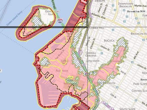
As part of ongoing post-Sandy evaluations, FEMA has released an early version of their updated Advisory Base Flood Elevations maps. “Snoooooze,” you say. “It’s not raining right now, this doesn’t affect me,” you say. Well, if you live anywhere near the waterfront, what this will affect pretty strongly is your Federal Flood Insurance Rate. So fun.
The map won’t be finalized for a couple of years, but FEMA is already advising communities to use it as “the best available flood hazard information,” mainly affecting areas we already knew were hazardous, like “Zone A” neighborhoods Red Hook and Gowanus. “I feel property owners in affected areas need to know right now what is being planned because it will greatly impact your plans for rebuilding,” said State Senator Velmanette Montgomery, whose district includes both neighborhoods.
Per FEMA’s recommendations, properties in said zones should be raised 3 feet above “Base Flood Elevation,” or risk facing way higher premiums on the Federal Flood Insurance (and also, presumably, being flooded next time a storm rolls around). The premiums would be so much higher, in fact, that a property 4 feet below base level could warrant charges of $9,500 per year, compared to $427 annually for a property just 3 feet above flood level. Geez. So, yeah. If this even has a possibility of affecting the place you live and/or own, maybe worth taking into account.
Follow Virginia K. Smith on Twitter @vksmith.